Martwa Wisła
Appearance
| Martwa Wisła | |
|---|---|
 | |
 | |
| Location | |
| Country | Poland |
| Physical characteristics | |
| Source | |
| • location | Vistula |
| Mouth | |
• location | Baltic Sea |
• coordinates | 54°24′36″N 18°39′39″E / 54.41°N 18.6608°E |
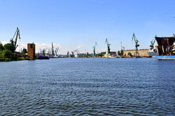
The Martwa Wisła (Polish: [ˈmartfa ˈviswa]; German: Tote Weichsel; both literally "dead Vistula") is a river, which is one of the branches of the Vistula, flowing through the city of Gdańsk in northern Poland.
It got its name when this branch of the river became increasingly moribund. A harbor canal was dug up with the Westerplatte on one of the Martwa Wisła banks. It was constructed to flow through Danzig (Gdańsk) into the Danziger Bucht, now Gdańsk Bay. Its river mouth and environs double as a harbor channel for the Inner Port of the port of Gdańsk.
See also
[edit]External links
[edit]![]() Media related to Martwa Wisła at Wikimedia Commons
Media related to Martwa Wisła at Wikimedia Commons
Page Template:Asbox/styles.css has no content.
Page Template:Asbox/styles.css has no content.

